|
Gleann
Cholm Cille - Glencolmcille

"The back of beyond" is one way Glencolmcille has been described.
Glencolmcille is nestled deep in the northwest corner of the island of Ireland.
It is the Irish equivalent of a dead end. The road literally stops here - any
further and you hit the Atlantic Ocean! Explore the beauty of Glencolmcille click
here
It is not surprising that Glencolmcille is rarely on a standard itinerary
of the Irish countryside. You need to be determined to get here. However,
the
stark beauty of the landscape has been attracting visitors for over 1500
years, while farming people are known to have been settled in the valley
as far back
as 3000BC. There are many remnants of these settlements
and visitations visible
to this day.
 Glencolmcille
owes its name to St. Columba, one of Ireland's three patron saints, who came
to this far flung glen in the 6th century. The name Glencolmcille,
or "Gleann Cholm Cille" in the Irish language, literally means "The
Glen of St. Columba's Church." Monuments of the early Irish Christian
era are numerous: the standing stones emblazoned with Christian crosses,
the ruined cells and even the place names are a reminder that the parish
was a
place of monastic activity perhaps as early as 450 AD. Glencolmcille
owes its name to St. Columba, one of Ireland's three patron saints, who came
to this far flung glen in the 6th century. The name Glencolmcille,
or "Gleann Cholm Cille" in the Irish language, literally means "The
Glen of St. Columba's Church." Monuments of the early Irish Christian
era are numerous: the standing stones emblazoned with Christian crosses,
the ruined cells and even the place names are a reminder that the parish
was a
place of monastic activity perhaps as early as 450 AD.
Fine beaches and cliffs make for excellent hiking in all directions. A
five mile walk southwest from Cashel, in Glencolmcille village, leads
to Malinbeag.
This coastal area was once notorious for smuggling. A trip to the Silver
Strand will reward you with stunning views of a gorgeous beach surrounded
by rocky
cliffs, and maybe with a swim in its calm, crysal-clear waters. Glen
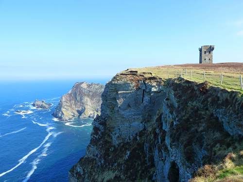
Head, a peak identifiable by the Martello tower at its peak, can be viewed
from
the Folk Village and is an hour's walk from Cashel through lands rich
in prehistoric
ruins, including St Columba’s Stations of the Cross.

If you decide to stay in Glen for a while, accommodation to suit all tastes
and budget can be found through the Tourist Information Office located in
the Lace House, Cashel. If you would like to find out more about the Irish
language
and culture, or join in a week of painting, Oideas
Gael run courses throughout
the summer. You can even combine an Irish
language course with hill-walking,
or join the local hill walkers
group, Sliabh Liag Walkers. Walk the Turas,
or pilgrimage, encompassing a round of megalithic tombs, natural features
and
cross pillars known as ‘Stations’, or enjoy a seisun of traditional
music in one of the local pubs. For musicians there are also Donegal
fiddle classes, workshops and traditional music courses in the area.
Further afield, golf is available at Narin and Portnoo Golf Club and surfing
in Dungloe,
Rossnowlagh, and Bundoran.

|
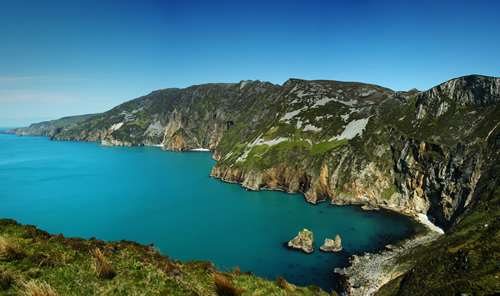
Slieve League Cliffs / Sliabh
Liag
Slieve League's cliffs reach almost
three times higher than the Cliffs of Moher in County Clare.
The Belfast naturalist Robert Lloyd Praeger wrote in 1939:
"A tall mountain of nearly 2000 feet, precipitous on its
northern side, has been devoured by the sea till the southern face
forms a precipice
likewise, descending on this side right into the Atlantic from the
long knife-edge
which forms the summit. The traverse of this ridge, the "One Man's
Path", is one of the most remarkable walks to be found in Ireland
- not actually dangerous, but needing a good head and careful progress
on a stormy day.... The northern precipice, which drops 1500 feet into
the coomb surrounding the Little Lough Agh, harbours the majority of
the alpine
plants of Slieve League, the most varied group of alpines to be found
anywhere in Donegal."

Photo courtesy of Conal McGinley
www.sliabhliagphotos.com / info@sliabhliaghphotos.com
Slieve League is often
photographed from Bunglass. It can be reached by means of a narrow
road that departs from Teelin.
The final few kilometers of this memorable route is built along a precipice
and includes several places where it turns at the crest of a rise. In
clear weather there is a dramatic view of Donegal Bay, and Ulster's highest
sea cliffs. Slieve League is a short twenty minute drive from the Folk
Village.

Shops, Fuel, Restaurants and Pubs in Glencolmcille
village
- Two stores sell general provisions; one also sells fuel.
- There is a sit down/take-away café next to the Tourist
Office.
- A licensed family restaurant (An Chistin)
is located next to Oideas
Gael,
a short walk from the Folk Village.
- There are two pubs, which feature traditional music sessions in
the summer.

Accommodation
There is a wide availability of accommodation options within
walking distance of the Folk Village from Dooey Hostel (074 9730130), Ionad
Siul Guesthouse,
self-catering cottages to B&B and pub rooms. See www.gleancholmcille.ie for
more information.

Doctor/Hospital
- There is a doctor in Carrick / Glencolmcille. Telephone: 9739380
- The nearest hospitals with full facilities are in Letterkenny (1h
25m) and Sligo (1h 51m).

Beaches
- Glen Bay Beach, opposite the Folk Village
- Silver Strand beach, a short drive along the Coast Road (R263).
|

